

TRACC travel time analysis software
The UK’s leading multi-modal transport planning software.
Accurately calculate travel times
Produce accurate travel times and distances for all public transport modes, cycling, walking and driving using TRACC Travel time analysis software.
Generate detailed what-if scenarios
Change your transport data or destination data to see changes in access and compare by utilising demographic data.
Get results in an instant
Outputs as you want them including detailed contours, thematic maps and numerous comprehensive reports.
Inefficient transport planning software can cost your business...
Save time
When trying to process detailed data, TRACC allows off the shelf information to be processed quickly and efficiently saving organisations time and money.Transparency in outputs
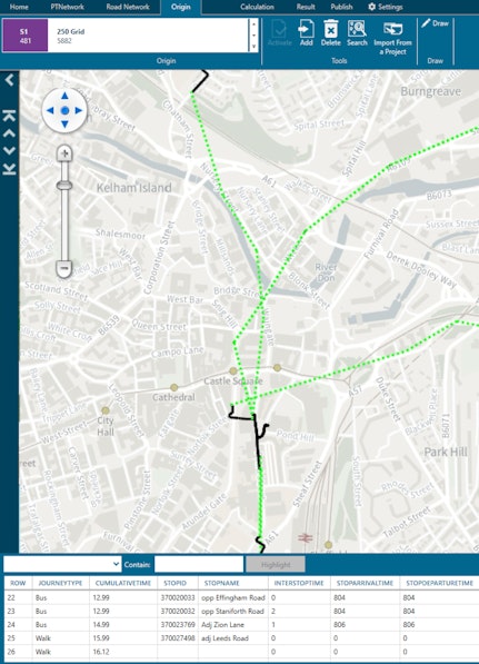
Using authoritative datasets, analysis done within TRACC is fully transparent with journey times and routes able to be exported from the system, removing any doubt in the results.Stay ahead of the competition
With over 2000 users of TRACC all over the world trusting the detailed analysis that TRACC produces, are you using the best tools to look at access?Enhance your view of access
TRACC is more than just travel times, you can look at detailed reports such as Hansen and PTAL to have a deeper dive into travel accessibility.
Download datasets
TRACC utilises detailed public transport, road, point of interest (POI), demographic and location data to create detailed analysis.

Customise your data
Once you have the data in TRACC you can make adjustments, such as create a new walkway, cycleway or bus route to model to a new POI.

Publish your results
Once you have the data loaded and edited, you can choose to export the results into detailed visual outputs or comprehensive reports.

Advanced public transport analysis
As well being travel time analysis software, TRACC also allows detailed analysis that can show: -
- How many times a service is utilised
- Population catchment within each service area
- Service Frequency analysis
- Detailed service information
- Peak Vehicle Requirement
- Total bus mileage
- Estimated costs
- Relationship between walking and public transport
With the ability to edit the data, it is possible to look at putting in a new bus lane or road works across a corridor and see how this affects access. Or edit or create new trips and services within TRACC, utilising the auto tri time calculator. All of this can be seamlessly done within TRACC.


Analyse with authoritative data
TRACC transport planning software efficiently loads diverse datasets, ranging from open-source and internal organisational data to authoritative datasets from leading mapping suppliers.
Data loaded
- Authoritative data from Ordnance Survey, TomTom, HERE, INRIX
- Open Data from Open Street Map, Overture, Ordnance Survey
- Load in average speed and speed limit data
- Detailed public transport schedules
- Point of Interest information
- Demographic data, points and boundaries
- Load your own data


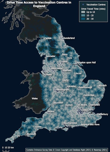
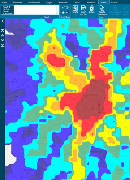
Visual travel time maps
TRACC generates detailed isochrones/contours, displaying customised time bands and colours, providing a powerful visualisation of travel time and distance.
- TRACC offers individually styled thematic maps for in-depth analysis
- Showcase various service frequency levels at bus stops, closest destination analysis, or individual routes, among other options
- Export to third-party software.

Versatile output options
TRACC features a powerful reporting engine that can create various unique reports on a huge range of travel metrics, from routes, time spent, distance, and high-frequency stops to demographic accessibility, personalised journey plans, and PTAL/Hansen access scores.
Using TRACC has allowed us to get much more accurate results; we can put in the whole of our regional bus, rail and road networks, visualising access better to make decisions.

Joanne Keay
Strategy Officer, Staffordshire County Council
Analyzing accessibility in small geographies such as census blocks reveals hotspots with very poor accessibility that will not show up when bigger geographies are used. TRACC helped us estimate travel times and accessibility between tens of thousands of census blocks within a reasonable time-frame, a task no other software I was familiar with was able to handle.

Amir Poorfakhraei
Senior Transport Planner, East-West Gateway
How it works
Getting started with TRACC is simple.
- 1 Request a demo of TRACC transport planning software
- 2 Select a license that suits your business needs
- 3 Calculating accurate travel times and output your results

License options to suit every business
Standard Desktop
This user has access to transport planning software capable of undertaking large calculations.Remote Server
Access remotely, covering cloud services in addition to local installations.Concurrent
Install on multiple machines/servers, access is controlled via active users.TRACC Web
Access TRACC anywhere in the world without using capacity on your machine, includes automatic backups and updates.Success Stories

TRACC used to overturn decision to close NHS emergency centre
In the spring of 2014, Somerset CCG set out to discover how a proposed centralised stroke service, based at Taunton Hospital, would affect the population of Somerset as a whole

Improving Parking Permit Systems and Promoting Active Travel
Oxford Health NHS Foundation Trust (OHFT) needed to introduce a sustainable car parking permit solution for staff, patients, visitors and service users following increased pressure on their existing car parks.

Department for Transport Uses TRACC to Inform Policy Decisions
The UK Department for Transport (DfT) have been developing and publishing journey time statistics for over 10 years