
Driving Sustainable Development for Staffordshire County Council
| Client | Staffordshire County Council |
| Date | 06.07.2026 |

"Using TRACC has allowed us to get much more accurate results; we can put in the whole of our regional bus, rail and road networks, and now we can put in urban paths as well to show walking routes".
Joanne Keay, Strategy Officer, Staffordshire County Council
About Staffordshire County Council
Staffordshire County Council produce accessibility appraisals to support their district councils deliver housing and employment development in the most sustainable areas. They provide evidence in local long term planning documents by demonstrating travel time to services by walking, cycling and public transport. The transport planning team are also focused on reducing congestion and carbon emissions, and improving health and fitness by increasing the uptake of walking, cycling and public transport.
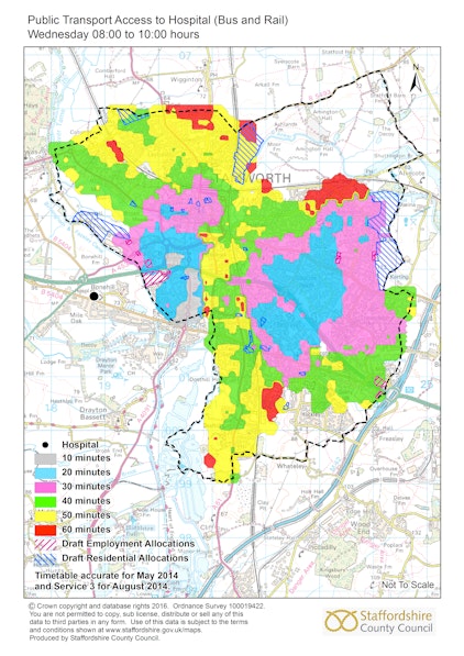
TRACC – accurate, multimodal travel time analysis
When calculating accessibility for public transport, TRACC takes into account the complete journey, so includes walk time to the stop/station, wait time for the service, in-vehicle travelling time and walk time to the destination and allows for interchange between services and modes. Due to the software's detailed analysis, Staffordshire County Council have been using TRACC for their travel time analysis.

The challenge - Prove accessibility developments
Tamworth and Newcastle Borough Councils required transport advice for proposals of developments in urban and rural locations where residents could make use of existing services and facilities to maximise travel choice and minimise additional travel by car. They also wanted to show that these developments were strategically placed for access to employment centres.
Tamworth was calculated using public transport for the majority of destinations with a maximum walking distance of 350m to a bus stop. For Newcastle, the parameters for maximum walking distance to a bus stop increased to 800m for their rural settlements. For schools, accessibility on foot was calculated as children who live beyond 2 miles for primary, and 3 miles for secondary school are provided with free transport.
Demonstrating Sustainability
In Tamworth, the results from TRACC ensured that the most sustainable sites had been selected, taking into account necessary improvements to bus services, so the local plan can go ahead. Newcastle is at an early stage but the results will help secure buy in during the consultation.
By using TRACC, Staffordshire are able to do work around scoping exactly what changes need to be made to travel (eg a new or extended bus service) so developers can review the evidence in the accessibility appraisal and commit to these changes. Joanne Keay, Strategy Officer for Staffordshire County Council, explains, "because we have put it through TRACC and we've added in new bus stops and services we know it will bring the benefits we are looking for, so the developers will hopefully just agree, or if not, we have the evidence to stand up against any objections"
Delivering fast and accurate results
Joanne recognises, "before we had TRACC, and its predecessor Accession, we didn’t do accessibility appraisals because doing it manually would take too long. Since using TRACC it has got a lot faster and now we are running through very large calculations really quickly”.
Staffordshire County Council has also used TRACC for securing money from the DfT for a new walking and cycling bridge to create a new connection across roads that were unsuitable for pedestrian access and are currently using it to promote walking and cycling routes to schools.